Silver Smithart → Texas A&M University Campus Map with Points of Interest©

TAMU Campus Map
by Chris "Silver" Smith '92
Published by the TAMU Press in 1995
24" x 36", Full Color on 2 sides
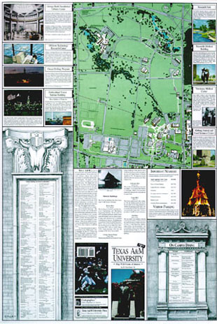
    The Map depicts the A&M Campus in its full glory -- the first ever TAMU map in Full Color! All of the buildings are shown in miniature 3D from a bird's-eye view above. The border surrounding the map contains small insets describing A&M's major Points of Interest. The Points of Interest include Art Galleries, Historical Displays, Sculptures, Scientific Displays, and other items of interest. This map is excellent for the campus newcomer and oldtimer alike. Perfect for Freshmen, Sightseers, and the old Ag who wishes to keep a reminder of the maroon homeland.

    The Map was projected up from a scale drawing of the campus and shows many new items such as the location of the new Special Events Center, the Library Expansion, and the George Bush Presidential Library.

Signed by the Artist!

    We sell the map in sets of 2 copies, never folded -- perfect for framing a front and back of the map diptych style for an impressive office wall or or home showpiece. One copy is signed by the artist on the front, and the other copy is signed on the back, making this quite rare -- few copies of the map have ever been hand signed for presentation.

    No other artist bears the distinction of having prints published by the University Press since the esteemed Buck Schiwetz portfolio of prints, issued in 1976!


TAMU Campus Map, by Silver Smith, Copyright 2009. All rights reserved.
Main Campus Side of Map
 

History of the Map

    The map was created during Smith's term as Manager of Administration of Cartographics (Texas A&M University's Graphic Art Studio for Mapping and Scientific Illustration) at A&M. After having created and published a number of versions of small, 8.5 x 11 campus maps, Smith hit upon the concept of creating a very comprehensive map which could contain not only the usual diagrams of where buildings and streets were located, but would also show major scenes and attractions for visitors. As further challenge, he sought to make the map artistically appealing for all of the dedicated fans of the University. As it turned out, the work took about an entire year altogether (in between other multitudinous campus publishing projects). A large number of offices throughout the TAMU Campus were involved in providing the information, as well as the Texas Department of Highways, and the research alone was considerable.

    The maps themselves were created the old fashioned way: by hand. Separation artworks were created from ink, mylar, and rubylithe. Each map (Main Campus & West Campus) required 8 individual layers of artwork - one for each color used on the map. Maps were drawn at 186% of final size, and the Main Campus Map's original separation art ended up being approximately 5' long -- quite a challenge to final compilation when you consider the amount of expansion and retraction the media begins to have due to temperature changes. All separation layers had to register perfectly for the final compilation.

    Most of the little vignettes in the border artwork were created by Smith, with the exception of a couple of photographs from the University's Archives and Collections. Each of the vignettes painted were created precisely to scale at 186% of final size so that they could be ganged up when scanned and reduced simultaneously for the final compilation. The original vignettes were acrylics on illustration board. Note the imaginative use of A&M's distinctive building stoneworks as a decorative element -- the two large relief sculptures used as borders for a list and the index were pencil renderings, and are characteristic of much of Smith's student artwork while studying in the College of Architecture.

    The cover price of the map is $3.95, but you're not likely to find any nonfolded, artist-signed copies of this anywhere else!

TAMU Campus Map, by Silver Smith, Copyright 2009. All rights reserved.
West Campus Side of Map


UPDATE October 2011:

 
The TAMU Press has allowed our original map to SELL OUT and go out of print!
As such, we are now providing a reproduction of the original map in a set of two prints - one print features the Main Campus side and the other features the West Campus. These are printed on a higher-opacity, thicker paper than the original map and are consistent in quality with the original map copies.
 
We will not be offering these prints for very much longer, so don't miss your chance to own a unique piece of A&M University art and history!
 

Payment & Shipping Information:

We Accept Personal Checks (payable to "Argent Leaf") or You May Pay With Credit Card or Bank Transfer Via PayPal
PayPal is a service allowing you a secure way to make credit card payments online.

Click the PayPal logo below to purchase now online:


$199.95 for a front-plus-back set suitable for framing.

Buyer will pay shipping + insurance fee of $10.00. We ship via UPS ground (typically 3-5 day turnaround in Texas and bordering states). We only ship prints in heavy, high-quality mailing tubes to insure artwork does not arrive damaged.